The "Paintbrush to Cascade Canyon" loop.
June 2024
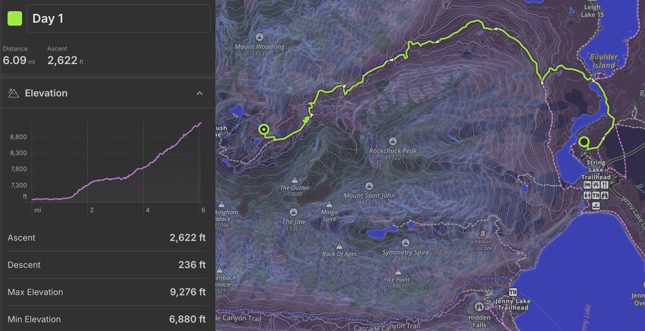
Recorded hiking distance: 21 miles (exactly) Recorded Elevation gain: 3,875 ft
Hiking time: Aprox 22 hours over 3 days with two nights spent on the trail.
Typical Gear we brought on this trip:
It was a 2-3 night trip in alpine/mountain conditions, so gear including but was not limited to water proof hiking boots, warm sleeping bags, heavier jackets/coats, tents, (some of us usually hammock- but not always recommended in cold conditions), gloves, and hats. All of this with the following specialized gear added some weight. Plan on 10-15 extra lbs to backpack in these conditions vs lower altitudes or later-sumer conditions where you wont deal with snow.
Specialized gear we brought for this trip:
Micro spikes and ice axes- with Jeff opting for trekking poles. Phil carried and extra 100ft of "ice floss" climbing rope and an smc snow anchor. The holy spirit carried an extra anchor. everyone carried either extra webbing for an emergency harness, with trent bringing a full harness. Why? The national park service strongly recommended the spikes and axes for the time of year we were attempting the climb. Still lots of snow up there in late June.
A working guide to our trip to the Grand Tetons- at Teton National Park
One of the worst parts of this trip is campsite availability- and distance between campsites, as there is no camping apparently in cascade canyon, so its a 7 mile stretch no matter what. Also IMPORTANT*** READ THIS BEFORE HIKING***, do not underestimate the need for BOTH the recommended microspikes/crampons and ice axe. These were absolutely necessary in late June, as you cross many (as many as 10)snow fields that are steep enough for you to take a nice slide down to certain paralysis or death.
We stayed at a nearby campground (outside of the park) on a Wednesday night in late June. After a lovely breakfast near the visitor center,
 we started our hike late morning, roughly 10:30.
We did this trip counter-clockwise, starting and finishing at the Leigh Lake Trailhead parking lot at these coordinates: 43.78850, -110.73045 .
we started our hike late morning, roughly 10:30.
We did this trip counter-clockwise, starting and finishing at the Leigh Lake Trailhead parking lot at these coordinates: 43.78850, -110.73045 .
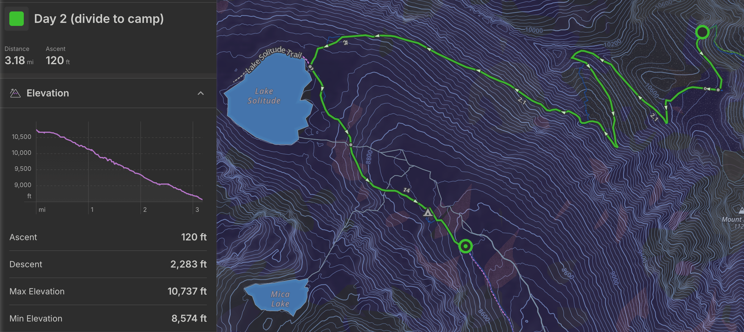
The first day was fairly uneventful, with some good steep climbing. Much of this hike has a good incline to it, so be prepared to climb. Jeff always brings treking poles which he says helps his knees. Its about 6 miles exactly from the parking lot to the group site which is about half way between the main trail, and Holly Lake. You will notice on our trail map that we got a little lost trying to find camp because the trail was fully-snow roughly a half a mile before the turnoff. (See our route on the MAP)
What a campground. Covered in snow, and had a few heavy streams running right through the middle.
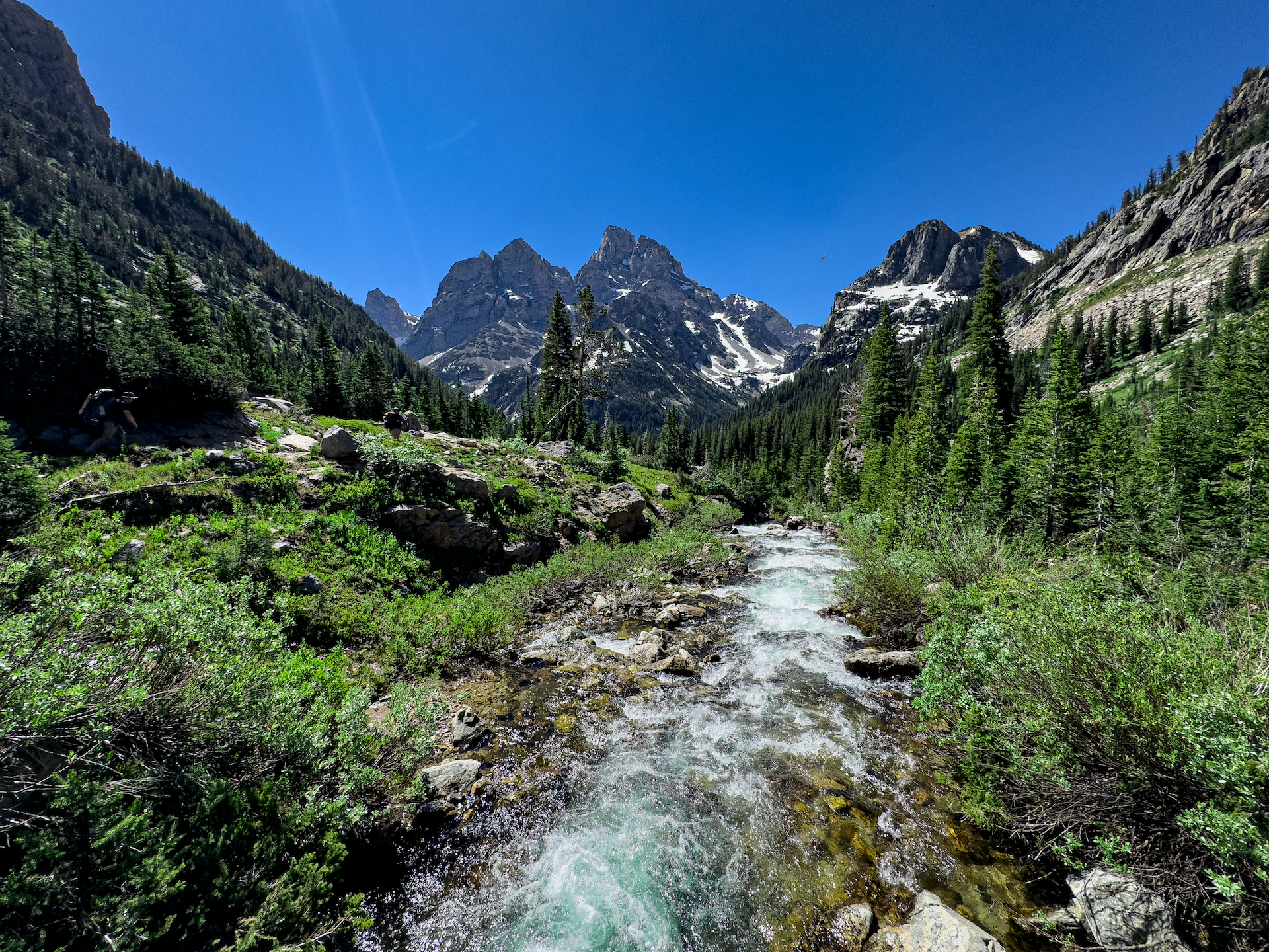
 >"Most of us pitched our tents in the only small clearing while Phil pitched his across the river, alone, on flat ground. We hiked 20+ miles through Yellowstone a few years ago and saw no bears, so we were thrilled to see an adult bear roughly 200 yards from our camp. The camp had a nice spot near a ledge that looked back down paintbrush canyon- epic view. In addition to the bear, a fox, and a dear walked right into our camp. The dear acted like it was scared (maybe because of the bear)and kept coming back and got right close to us. Nice place to camp- would be much nicer I imagine in mid July.
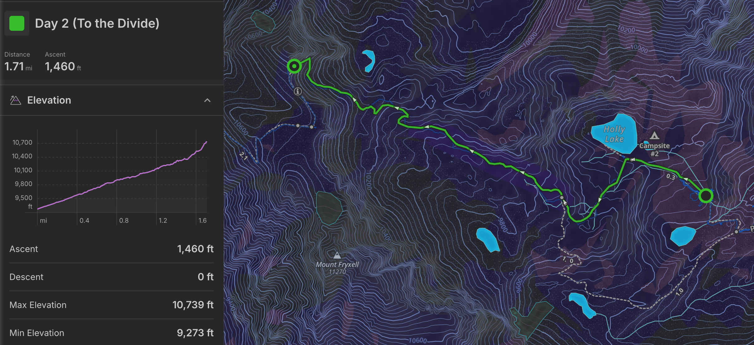
On day 2, we took a long, good ol time taking our time slowly getting ready to hike- probably because we knew what was coming and we were procrastinating- but didn't get started till about 1030. Not recommended. Starting this late put us into a makeshift campsite just before dark- Had we started a few hours earlier, we would have had ample time to make it to a better spot. Here is another example where campsites are not very evenly distributed along this trail, forcing middle aged- average shape people to hike maybe longer than they would otherwise like. But, we geared up for some serious snow trekking with micro-spikes, and ice axes/trekking poles. It was a good hike in the snow for nearly 2 miles to the peak/divide. (its not an actual mountain peak- more like a 'saddle')
It cleared up (snow wise) maybe 1/4 mile from the top, other than a few snowfields which are steep and dangerous- a few people we passed on the way here had turned back because they had not brought spikes or axes- including 1 mountaineer. We also ran into a some people hiking with a young stranger who they rescued from certain death- as he had attempted to slide down from the other side of the divide (clockwise) without ANY gear. We could see the spot he attempted to slide down as we got higher, and apparently it was only because one of the passers by was able to grab him that he didn't slide down another 500 feet to rock and boulders.
Lucky for us, we had researched the trail and conditions thoroughly and came prepared. Over-prepared actually, as we brought 100ft of climbing rope and a couple snow anchors- adding some good weight to Phils pack. A 1/4 mile from the top, we sat and watched some people cross the divide to make sure it was possible- the actual trail was covered by an extremely steep ledge of snow (think vertical ice climbing)but the people were able to make it over from both directions scrambling over the rock to the side. So, we made our way to the top, and used the rope as a safety for those in the group who were less comfortable scrambling on steep rock, and made it up over the top. Marmots, marmots, marmots everywhere.
After that its a long slog down to a spot to camp-passing Lake Solitude which was mostly frozen. (a surprise- as recent online reports had described it as mostly thawed... take online reports with a grain of salt!) On your way down to the lake, you can cross several more snowfields this time of year, watch your step. We had heard that you could slide down this side of the mountain and save some hiking down a few switchbacks. Phil, whos feet were soaking wet opted to slide down on his rear using his axe as a brake. According to him- it was well worth it. Ideally we would have stayed in the group site just past lake solitude- but it had been booked already when we got our permits in January-2024. The extra time added some good fatigue, and one in our group fell ill- likely to dehydration and lack of electrolytes. The result was a late arrival to camp, so we pretty much ate a quick meal and went right to bed in a small damp meadow just off the trail. Nice spot though considering, and had some great rocks to stand on to take some epic pics in front of Grand Teton.